
Forest Ecosystems In A Changing World
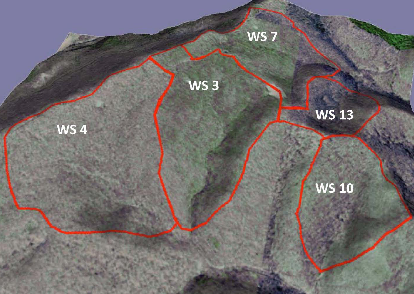 The Fernow LTREB is focused on long-term records from five small watersheds (WS 3, 4, 7, 10, & 13), and a unique set of experimental plots - the Long Term Soil Productivity (LTSP) plots.
The small watersheds include three reference watersheds (WS 4, 10, & 13) that are especially interesting because they differ greatly in the amount of nitrate lost in streamflow, despite being in close proximity to each other and having the same land-use history, geology, and dominant soil series.
Click here for a more details about the small reference watersheds.
The other watersheds (WS 3 & 7) are part of a long-term watershed acidification experiment. Both have forests that began regenerating ca. 1970 following clearcutting. Since 1989 WS 3 has recieved ammonium sulfate additions to accelerate the acidification process.
Click here for a more details about the Whole-Watershed Acidification Experiment.
Chronic acid deposition may diminish soil fertility and forest productivity. To rigorously assess these concerns, the LTSP experiment was initiated in 1996 and is planned to last 80 years.
Click here for a more details about the LTSP experiment.
The Fernow LTREB supports long-term hydrological, chemical, and vegetation measurements in the reference watersheds, whole-watershed acidification experiment, and LTSP experiment.
Click here for a more details about the long-term measurements being made.
 Listen to Jim Kochenderfer give a brief history of the Fernow to creative writing students near the top of WS 7 during the summer of 2014. Jim was a research forester at the Timber and Watershed Lab from 1967 until his retirement in 2006. During this time he investigated aspects of forest hydrology and silviculture.
 General Description
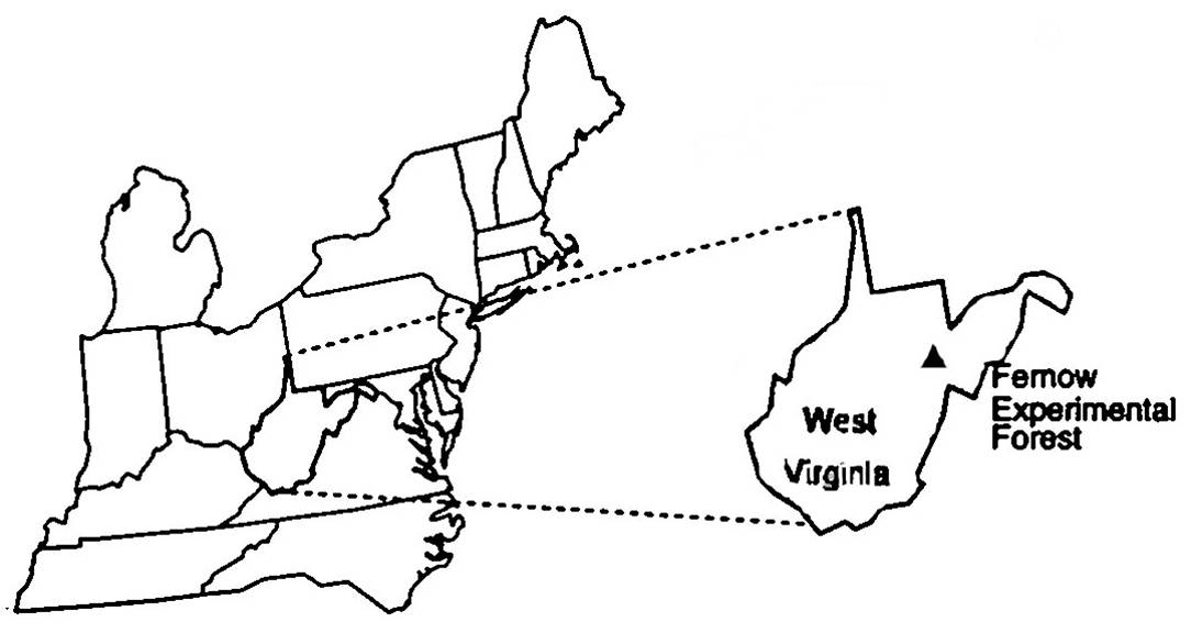
The 1,902-ha Fernow Experimental Forest (FEF) is located south of Parsons, West Virginia. The Elklick watershed (which later became the bulk of the FEF) was initially logged between 1903 and 1911. Most of the watershed was not farmed and the forest was allowed to regenerate naturally following the cessation of logging activities. The federal government purchased the land in 1915 and dedicated it to forest and watershed research in 1934. The Elklick basin (FEF) was selected as a research location because of its good soil, excellent young regrowth, and because it was considered to be representative of more than 5 million ha of mountainous forestland in West Virginia and adjacent states. Since 1915 there has been no record of significant insect defoliation or fire, and grazing has been prohibited. However, chestnut blight in the 1930’s resulted in a short-term, but significant (25%), reduction in standing volume on the experimental forest.
The FEF is located in the Allegheny Mountains Section of the Central Appalachian Broadleaf Forest, and vegetation is classified as mixed mesophytic. Characteristic species include northern red oak (Quercus rubra),yellow-poplar (Liriodendron tulipifera), black cherry (Prunus serotina), sugar maple (Acer saccharum), sweet birch (Betula lenta), red maple (A. rubrum), and American beech (Fagus grandifolia). The topography is mountainous with elevations ranging from 530 to 1,115 m above sea level. Slopes of 20-50 percent are common. Soils are predominantly from the Belmont and Calvin series and consist of moderately deep, well-drained soils formed in parent material weathered from interbedded shale, siltstone and sandstone. Average soil depth is about 1 m, and a considerable amount of stones and large gravel is present.
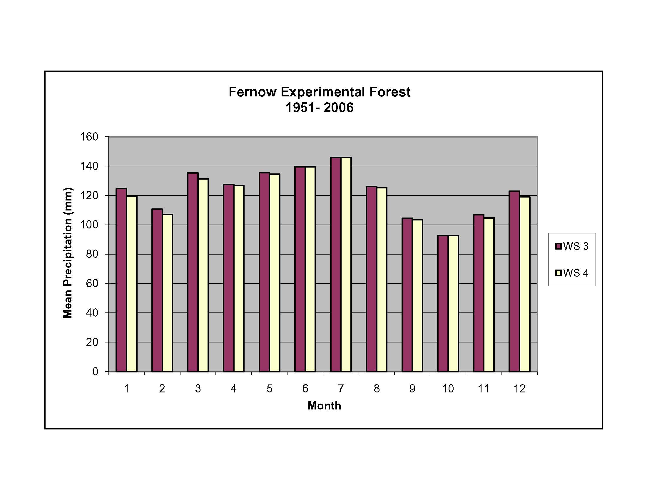
Research in forest hydrology began at FEF in 1951 when five watersheds were instrumented to measure precipitation and streamflow. Currently streamflow is measured for ten watersheds within the FEF and two watersheds with the longest record of streamflow at FEF (WS3 & WS4) are part of the LTREB project. There are seven precipitation monitoring stations located within the FEF, and an eighth station is located ~5 km northeast but at a lower elevation (~510 m). The lower-elevation station has been a part of the National Atmospheric Deposition Program since 1978 (NADP site WV18), and part of the National Dry Deposition Network (CASTNET site PAR107) since 1989.
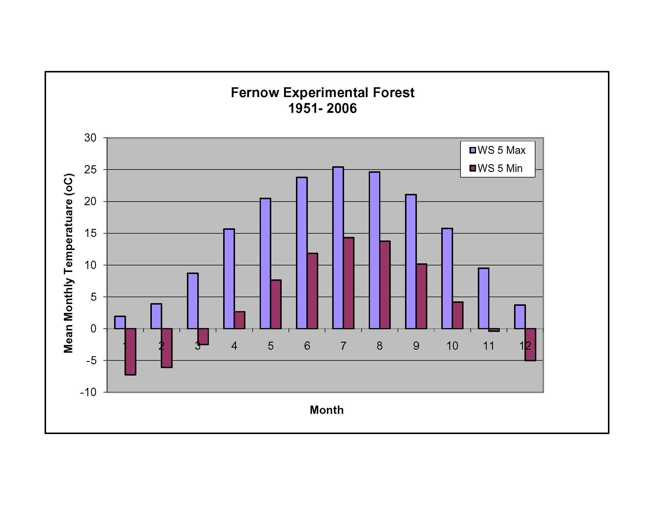
Mean annual precipitation for FEF is about 1,480 mm, and is distributed evenly throughout the year. The growing season is May through October with an average total frost-free period of 145 days. Snow is common, but any snowpack generally lasts no more than a few weeks. The mean annual temperature is 9.2 C but temperatures can reach -20 C most winters. Watersheds at FEF receive relatively high inputs of inorganic N and S from atmospheric deposition. Between 1982 and 1993 we estimate that the FEF received an average of 6.7 kg N/ha*yr in wet deposition alone, which is an amount greater than 93% of the observations reported during the same period for 197 sites in the contiguous United States and Canada. When dry deposition estimates for N and S gases are added to measurements of bulk precipitation inputs, then the total N and S inputs to FEF were ~10 kg N/ha*yr and ~20 kg S/ha*yr between 1986 and 2002.