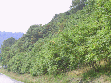
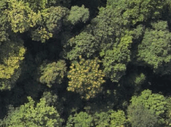
Ailanthus stand near Morgantown, WV (far left). Birds' eye view of female Ailanthus from Piper Apache (left).
Invasive Potential of Ailanthus altissima (Tree of Heaven)
and Related Remote Sensing Research
In Fall, 2002, we started a project to understand the invasive potential of Ailanthus altissima, a tree becoming known to us as 'Tree of Almost Heaven' (with apologies to John Denver). This work was funded by two major grants from the USDA (2002-2005) and NASA (2004). I am increasingly willing to stick my neck out and claim that Ailanthus may be the most serious invasive tree species threat to the eastern deciduous forest, both economically and ecologically. There are several objectives this research, including (a) quantifying short- and long-distance dispersal across the landscape, (b) developing remote sensing and image processing techniques to differentiate female and non-female Ailanthus from aerial imagery, (c) studying the present distribution of Ailanthus across the landscape using GIS in combination with vehicular and airborne geopositioning, (d) comparing the germination and establishment of Ailanthus in the forest compared with native colonizing species.
Colleague Tim Warner in the Department of Geography has worked on the remote-sensing and image-processing elements of this work, and is currently supervising MS student Aaron Burkholder's project on 'phenospectral' variation in Ailanthus, comparing it's reflectance properties with native species throughout the season. Rick Landenberger used his extensive experience in studies of edge species population dynamics to advantage in overseeing all project objectives; he recently authored an upcoming article in Urban Ecosystems, describing the distribution of Ailanthus across the urban-suburban-rural interface near Morgantown, WV. Masters student Nathan Kota’s work focused on the comparative elements of dispersal and establishment for Ailanthus and native tulip poplar (Liriodendron tulipifera). Matt Kaproth completed his MS thesis on modeling of dispersal across the landscape, including dispersal by water (in press; Forest Science).
|
|
Ailanthus stand near Morgantown, WV (far left). Birds' eye view of female Ailanthus from Piper Apache (left). |
The Ailanthus project is an extension of my lab's long-term interest in using remote sensing as a way of remote censusing: literally collection of data for population projection matrix models using the tools of remote sensing and image processing. Working closely with Dr. Tim Warner (Dept. of Geology and Geography), we attended conferences and obtained seed grants beginning eight years ago to explore the possibilities. Encouraged by the response, we wrote a major grant to NSF and were funded in full to work on the computational aspects of distinguishing tree species and individuals from aerial imagery. This research resulted in several publications, particularly with postdoctoral research associates, Rick Landenberger and Tomas Brandtberg.
 |
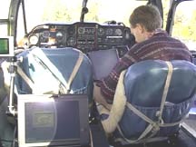 |
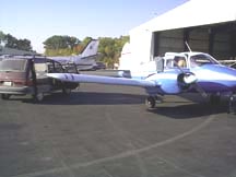
Twin-engine Piper Apache aircraft used for digital imagery acquisition by forest remote sensing project (far left). Collaborator Dr. Timothy Warner preparing GPS system for takeoff. |
Currently, the demographic work on Ailanthus is occurring primarily on the ground, where PhD student Alyssa Hanna has been taking detailed demographic measures of several small populations to try to understand the controls over spread of this species. We are attempting to use RAMAS GIS software to produce spatially explicit models of population spread across the landscape. Alyssa' other studies are examining the importance of Ailanthus as a competitor with other native species, from native trees to herbs, such as ginseng.
Note: At present (Fall, 2010), I do not have funding to support projects specifically on remote sensing or invasive species, unless they pertain to effects on wild harvested plants, such as ginseng.