
Forest Ecosystems In A Changing World
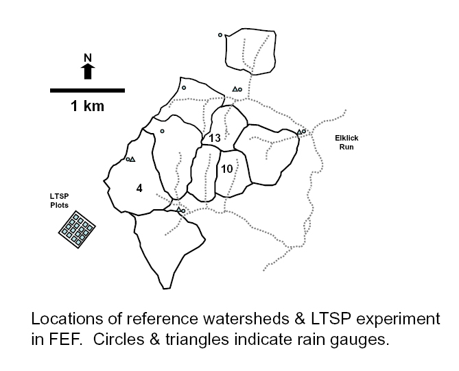
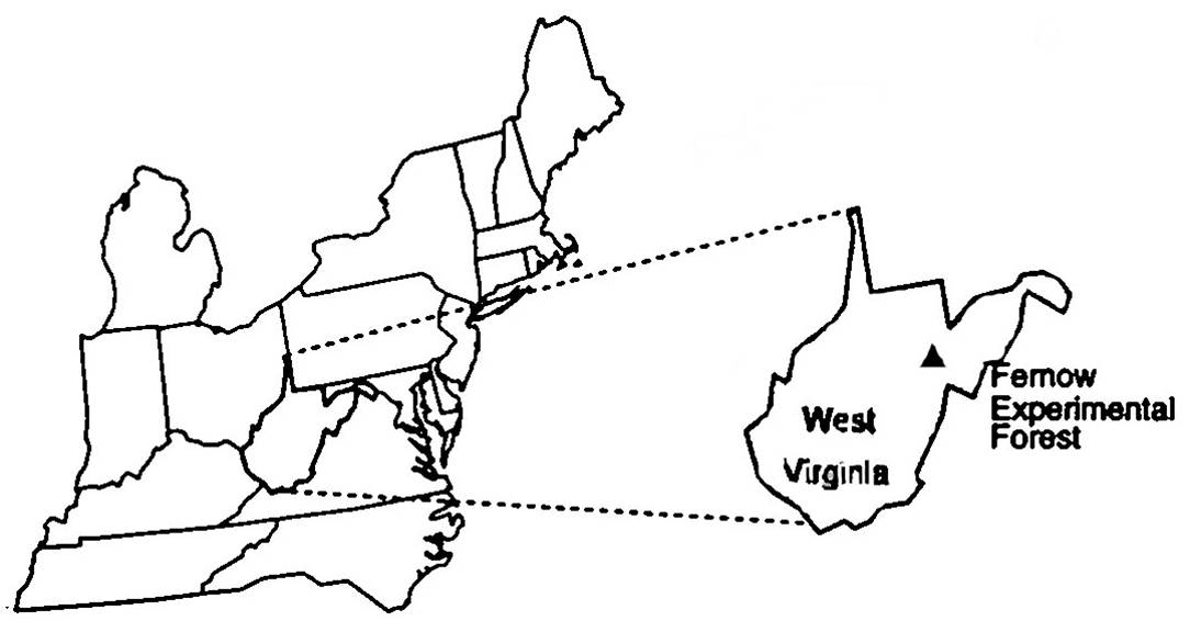
Location of reference watersheds
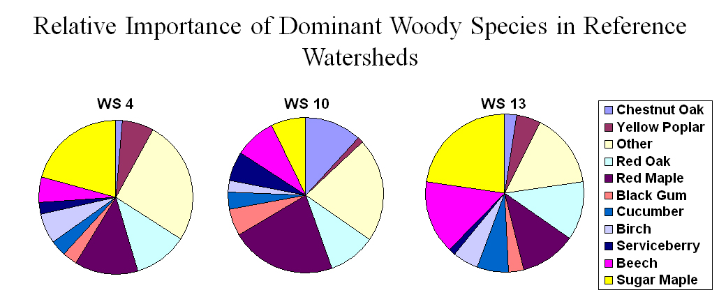
Tree species composition.
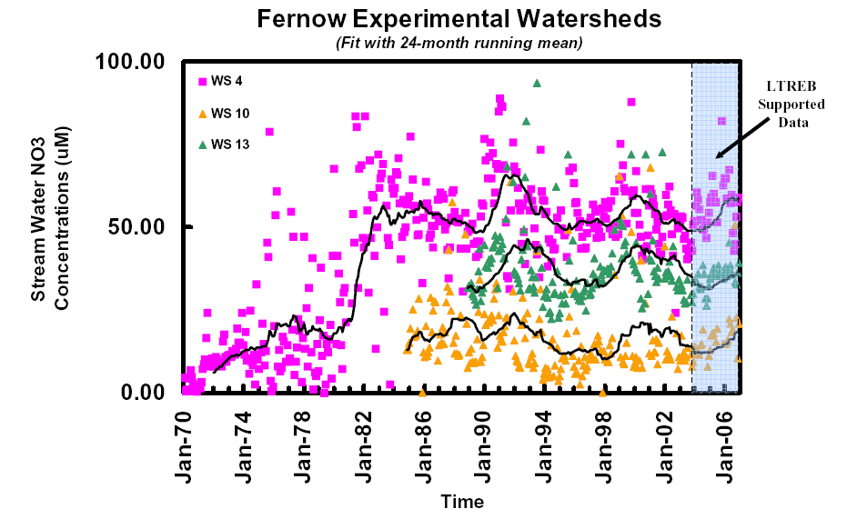
Long-term stream-water nitrate concentrations
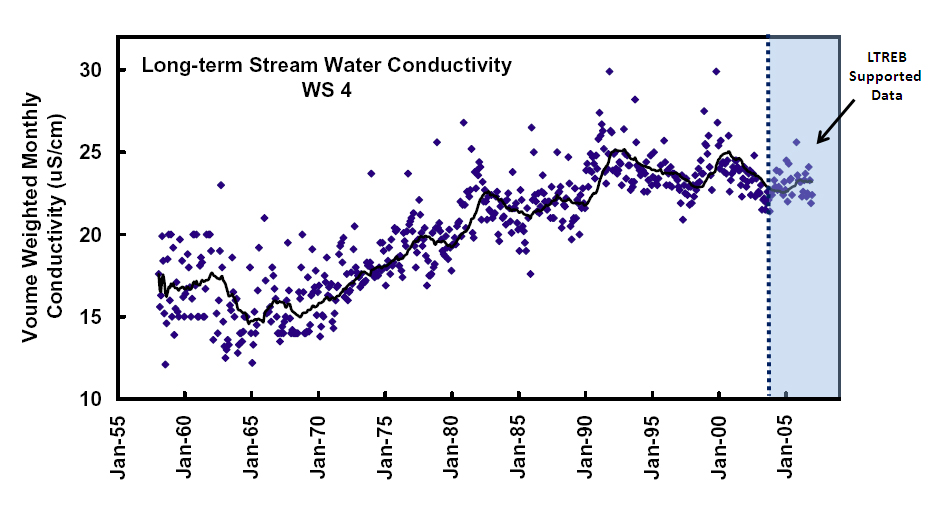
Long-term stream-water conductivity for reference WS 4
 Reference Watersheds
An important feature of the Fernow LTREB are long-term datasets from three reference watersheds that have remained undisturbed by direct human activities since being heavily cut around 1910 (WS 4, 10, & 13). All three watersheds are < 2 km apart and share the same dominant soils series, geology, climate, stand age, and land-use history. Furthermore, none of the forests in these watersheds have experienced severe insect defoliation, grazing, or fire in the last 90 years. However, despite their similarities, the response of these watersheds to chronically high levels of N input from the atmosphere has been strikingly different and may be related to differences in the composition of tree species. Such variability has also been found at larger spatial scales in the Catskills and points to the value of replication when trying to generalize about ecosystem response to a changing environment.
Continuing the long-term records from these reference watersheds will provide valuable information on the response of forested watersheds to long-term changes in atmospheric deposition in the absence of substantial differences in other factors that often confound comparisons done at regional or larger scales (e.g., geology, climate, and land-use history).
Among the reference watersheds, watershed 4 (WS 4) consists of 38.7 ha with an average slope of 16% and an east-southeasterly aspect. The vegetation is dominated by sugar maple, red maple, red oak, tulip poplar, and sweet birch. Measurements of streamflow began in 1951, stream-water conductivity in 1958, and the concentration of other analytes in 1970. This results in a biogeochemical record that rivals the 46-year record of stream-water chemistry for watershed 6 at the Hubbard Brook Experimental Forest. Watershed 10 (WS 10) is smaller (15.2 ha), more steeply sloping (26%), and has a southerly aspect. The vegetation on this watershed is dominated by red maple, chestnut oak, red oak, and American beech. Measurements of streamflow and stream-water chemistry began for this watershed in November of 1984. Watershed 13 (WS 13) is the smallest of the reference watersheds (14.2 ha), with steep slopes (ca. 25%), and a north-northeasterly aspect. The vegetation is dominated by sugar maple, American beech, red oak, and red maple. In May of 1992 it received a one-time aerial application of Dimilin (35.1 g (AI)/ha which had no discernable effect on streamflow or stream-water chemistry. The biogeochemical record for this watershed is the shortest of the three, with measurements of streamflow and stream-water chemistry beginning in November of 1988. On all three watersheds the dominant soil type is a Calvin channery silt loam (loamy-skeletal, mixed, mesic Typic Dystrochrept) derived from the acidic sandstone and shale of the underlying Hampshire formation. From the existing long-term records, the average annual streamflows for watersheds 4, 10, and 13 are 64.0, 64.2, and 98.1 cm, respectively. The average annual stream-water NO3- concentrations for watersheds 4, 10, and 13 are about 50, 14 and 43 uM, respectively.